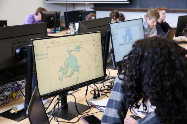
Cornell College students have a new space to collaborate after a classroom in Norton Geology Center was renovated to become a GIS (geographic information systems) lab.
Contractors upgraded the electrical systems and installed new carpet, projector, transitional seating, and two dozen large monitors. This is all thanks to a grant from the Sherman Fairchild Foundation, which awarded the college a total of $500,000 to fund new STEM equipment and upgrade facilities on campus.
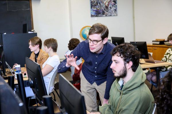
GIS students used the new lab for the first time during Block 6 with Assistant Professor of Geology Andy Walters. The GIS professor says the One Course At A Time schedule allows students to learn the fundamentals and then apply what they’ve learned through hands-on projects each day.
“This new lab provides a collaborative teaching space that makes it easier for students to get more hands-on with GIS than the typical Cornell College classroom,” Walters says. “The larger monitors and collaborative setup of this lab allow students to learn from each other and for me to support students as they practice using ArcGIS. This allows the class to be a mix of independent and collaborative learning.”
Junior Thomas Machande, a geology major, was in the Block 6 Geographic Information Systems course and said he enjoyed having a formal lab space to learn ArcGIS.
“I think it’s a really good space for team building, considering it is a computer software class. The lab really helps with class engagement and helping each other out,” Machande says.
GIS is a computer system designed for storing, managing, analyzing, and mapping geospatial data, which is data that describes features on Earth.
“If we wanted to know the density of population for an area, we can import that data from a government website and we can see the population of Mount Vernon, for instance, compared to Cedar Rapids through heat maps,” Machande says. “It’s a software that can combine any form of data to be turned into a map.”
Walters says several different majors signed up to take the first GIS class in the new lab, which is understandable because ArcGIS is a system used by many professional fields, including environmental science, earth science, urban planning, archaeology, engineering, public health, agriculture, business, and more.
“The goal of this course is to introduce students to the key principles of geospatial data and geographic information systems and give them hands-on time working with ArcGIS, one of the most widely used GIS programs,” Walters said. “Students then apply the knowledge they gained in the first two weeks of the course to a final project, where they develop a question that they are interested in investigating, find the geospatial data to address this question, and use ArcGIS to create a map that is able to shed light on this question.”
From the past to the present:
Norton Geology Center was once a Carnegie Library, which opened for students and Mount Vernon residents to use on Sept. 13, 1905. Two years earlier, two college Trustees approached philanthropist Andrew Carnegie, who was known for funding library projects around the country, and convinced him to finance the library to support the growth of the college.
Over the years, the building has been used for various majors and purposes. But in 1980 the college held a ribbon-cutting ceremony to reopen the building as Norton Geology Center, named after Cornell’s first geology professor–William Harmon Norton. Cornell’s Department of Geology is the oldest in Iowa, with course offerings dating back to 1855.
Fast forward to 2024, the Cornell facilities team and local contractors created a plan to complete another round of renovations on the third floor. Cornell Construction Projects Manager Scott Ladwig, who has worked on many campus buildings, including King Chapel and Law Hall, says he’s always impressed by the construction of Cornell’s historic campus.
“Really what I find is a piece of our past when we are working on these buildings, but we also find a lost trade,” Ladwig said. “They weren’t built with the technology we have today, but these buildings were made to last.”
And 118 years after the building first opened its doors, the technology advancements are creating opportunities that students a century ago would never have dreamed of seeing.
“The GIS lab was designed to provide students the flexibility for in-class learning while also being able to continue their studies from other areas on campus,” said Interim Director of Information Technology Tim Messick. “Students bring their laptops to class and have the ability to connect to a 24-inch monitor for a larger workspace. Students have access to industry-standard GIS mapping software delivered via a virtual Citrix environment, which allows them to run it from a server on campus and stream it to their laptops.”
Walters expects to teach the GIS course each year in the newly opened lab.
All photos taken by Megan Amr in the GIS lab during Block 6 of 2024.
Norton Geology Center upgraded with GIS lab
April 11, 2024

–Contributed photo by Megan Amr
Students work on mapping projects in the new lab during Block 6 of 2024.
--Contributed photo by Megan Amr
Assistant professor of geology Andy Walters (left) helps his students with their projects in the GIS Lab.

